![[GUIDE] Taliis and Terrain Editing!!!! - Revision 2](https://www.ownedcore.com/forums/images/styles/OwnedCoreFX/addimg/menu4.svg)
EDIT - Thanks for the suggestions, here is a better rendition with COLORS and images thanks to Reflection suggestion! Also fixed a typo that woulda confused some!
Taliis and Freeworld3D Map Editing
by DJRehab exclusively for mmowned.com
VERY IMPORTANT - TALIIS CURRENTLY DOES NOT IMPORT HEIGHT MAPS CORRECTLY AND THIS DOES NOT WORK WITH CURRENT TALIIS RELEASE...THIS IS NEARLY A LITTLE PREVIEW OF WHAT TO DO WHEN THE IMPORT HEIGHTMAP FROM PNG FUNCTION IS WORKING!!!!!!! ALSO IF YOU ARE UNFAMILIAR WITH HOW TO PACK AN MPQ FILE OR EXTRACT FILES FROM AN EXISTING MPQ FILE LEAVE HERE....LEARN HOW TO DO THAT...THEN COME BACK!
That being said...you can, however, export heightmaps correctly and edit them now, and just inject them at a later date when Taliis has a better import script.
INTRO:
My computer sucks. Everytime I run NoggIt...CRASH!!! Everytime I run YiasDX....CRASH!!!! Then I found Taliis and almost creamed in my pants. Sure it is not as good on the eye candy as NoggIt, but i can run the thing so all is well!
First time I ran it I instantly dove in and opened one the Azeroth ADT files and was waiting for the big crash. Wow, no 3D view so I wont crash due to my on-board graphics card which internally sucks testicles. With this tool you can export and import heightmaps (which is how we will edit terrain forms) and also change textures, edit doodads/WMOs , and pretty much everything in the level (just takes time to do all this manually crunching numbers where noggit and yias offer easy interfaces at the expense of being bugged up pieces of crap imho).
Here I will attempt to teach you how to edit ADTs with Taliis and a few third party programs available online (Freeworld3D is not freeware despite the name but you know what to do...) Below is a list of tools I will be using although i am sure there are alternatives to the third party programs that you may even have installed already!
Taliis - Great program for editing different WoW filetypes including .adt that is found HERE at MMOwned (use search dummy head)
WoW ME - Tool by somewhiteguy that doesn't work with current WoW versions but houses a database of Zone names and what map files are part of the Zone
Freeworld3D - A world editor that supports importing and exporting heightmaps
(dont ask me for a dam Freeworld3D key generator it is not legal and I do not support Google, search strings, nor "CORE keygen"s *HINT HINT DUMB NUTS*)
Paint Shop Pro (or photoshop, or Paint.net whatever one floats your bubble)
MyWarcraftStudio - Name one model edit that don't use this...if you dont have it yet you are a retard
Patience and half a brain
STEPS
Find ADTs and Extract Them
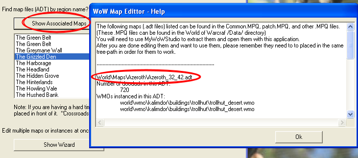
In the Model Editing Guides and Programs forum is a sticky thread of all WoW Model Editing Downloads in one place....get Demonkunga's tool and MyWarcraftstudio! In Demonkunga's tools is a handy tool called WoW Map Editor... run the WoWME.exe and the bottom list box contains all zones in World of Warcraft.
Click on the one you wish to edit and click Show Associated Maps. This will list all the .adt files that have part of whole of this zone in it!
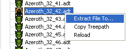
Use MyWarcraftStudio to open up .mpq files and find the .adt file(s) you wish to edit and extract them to a new folder somewhere.
Getting the heightmaps
Run Taliis and have it open the first ADT file (or only adt file whatever). Double click the adt file in the left list box to expand it into the seperate components of the ADT file and click Heightmap. It will then display the heightmap on the right of the window
In the menus go to Edit > Heightmap > Export to PNG
In your graphics editing tool open the heightmap png (NOT THE LOD ONE although i dont think it matters which one lol) and save it as a BMP file (Freeworld3D does not support PNG for some reason).
sorry no image for saving images it's kind of duh!
Import to Freeworld3D
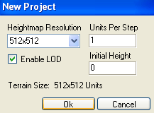
First off, Freeworld3D MUST BE FULL VERSION as the demo can not save height maps. Open Freeworld3D and in the menus select File > New Project. Set heightmap resolution to 512x512, Make sure LOD is checked, Units per step = 1, Initial Height = 0....Click Ok! I know 512x512 is kind of large but i use this for my own personal preference you can toy around later AFTER YOU FOLLOW THIS THROUGH and get a feel for it
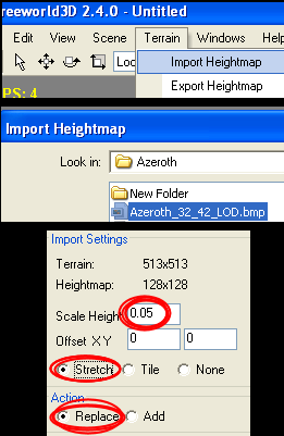
Next, in the menus go to Terrain > Import Heightmap. Select your converted heightmap bmp and click the radio button marked "stretch". Next set the Scale Height to 0.05 then press Apply!
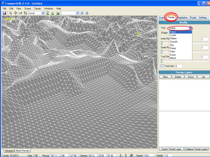
Use the Terrain Tab on the right hand docked window and there will be deformation tools (raise, lower, smooth, flatten, etc. pretty much like noggit terrain functions) and modify however you want!
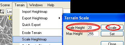
Now fix it to work correctly by changing the scale back. Go to the menu Terrain > Scale Heightmap. Set it to Scale Height = 20 and click Scale (this reverses the effect of scaling to 0.05 when importing the height map to work correctly with Taliis!!!). It will look all sorts of fudged up now, but it will work trust me
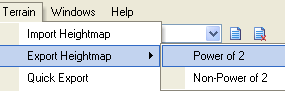
Go to menu Terrain > Export Heightmap > Power of 2 and save the image as 24-bit BMP file. Open it in your image editing program and and use the Select All function (usually CTRL+A) and then edit > copy.
Open the original heightmap.png (the non converted one that Taliis created and not the LOD one either...) and select all there as well. Use menu Edit > Paste > Paste into selection (In Paintshop Pro shortcut is SHIFT+CTRL+L). Now click save
Open the original heightmap_LOD.png and do the same as above. Select all and paste into selection then save.
If your program does not support Paste into Selection, just get the image sizes of the original two PNGs Taliis created and resize the modified BMP heightmap to match and save over the Taliis created PNGs!!! ----YOU MUST SAVE OVER THE ORIGINAL CREATED TALIIS HEIGHTMAPS FOR THIS TO WORK AS THATS WHERE TALIIS WILL READ FROM!!!----
Sorry the one above was last pic the rest should be simple to follow
Back to Taliis!
Open Taliis (if you even closed it, i dont) and reopen the ADT you edited the heightmap from. In the menu go to Edit > Heightmap > Import from PNG. If you have
heightmap visible on screen and notice no change its because it does not auto refresh...click something else (Like Alpha Layer or anything in the listbox) and than back to
heightmap. VOILA IT IS DONE!!!! of course current Taliis does not import the maps correctly but with a newer version (hopefully) this will be fixed!!!
Now just save the modified ADT file and make yourself an MPQ and woohoo!!! lol I did this although Taliis defuncts the heightmaps just to see and it totally screws the maps for now, but patience is a virtue...lol
NEXT TO COME
TEXTURE EDITING THROUGH ALPHA LAYER hehe bet ya can't wait and I haven't even tried this...it might work with current version!!!!! Will try tommorow
Taliis developer(s) - Contact me and we will get some work done
happy modding and I can NOT wait for a new Taliis that works with Heightmap importing!
THANKS FOR READING
Revision 2

![[GUIDE] Taliis and Terrain Editing!!!! - Revision 2](https://www.ownedcore.com/forums/./ocpbanners/1/2/9/8/0/2/2/01d9781faec8bfe3abf9095ac9e57d1e.jpg)
![[GUIDE] Taliis and Terrain Editing!!!! - Revision 2](https://www.ownedcore.com/assets/mm/images/wits.png "TradeSafe Middleman")
![[GUIDE] Taliis and Terrain Editing!!!! - Revision 2](https://www.ownedcore.com/forums/images/styles/OwnedCoreFX/addimg/wicc.png "CoreCoins")

Shout-Out
User Tag List
Results 1 to 13 of 13
-
04-14-2010 #1
 Active Member

- Reputation
- 42
- Join Date
- Jul 2007
- Posts
- 87
- Thanks G/R
- 0/2
- Trade Feedback
- 0 (0%)
- Mentioned
- 0 Post(s)
- Tagged
- 0 Thread(s)
[GUIDE] Taliis and Terrain Editing!!!! - Revision 2
Last edited by DJRehab; 04-14-2010 at 03:57 PM.
![[GUIDE] Taliis and Terrain Editing!!!! - Revision 2](https://www.ownedcore.com/images/ba/g/b2.gif)
-
04-14-2010 #2
Legendary

- Reputation
- 783
- Join Date
- Mar 2008
- Posts
- 3,377
- Thanks G/R
- 1/2
- Trade Feedback
- 0 (0%)
- Mentioned
- 0 Post(s)
- Tagged
- 0 Thread(s)
Approved. Great guide
 May I suggest a few changes though that helps with the overall impression?
Add a bit of color to your post to spice it up a little and an image really does help a long way!
Freelance Digital Artist
https://reflectionartwork.deviantart.com
You did not desert me
My brothers in arms
-
04-14-2010 #3
★ Elder ★


- Reputation
- 1179
- Join Date
- Jul 2008
- Posts
- 2,906
- Thanks G/R
- 94/51
- Trade Feedback
- 0 (0%)
- Mentioned
- 0 Post(s)
- Tagged
- 0 Thread(s)
Really nice and helpful, good job.
Xel approves!
-
04-15-2010 #4
Active Member
- Reputation
- 42
- Join Date
- Jul 2007
- Posts
- 87
- Thanks G/R
- 0/2
- Trade Feedback
- 0 (0%)
- Mentioned
- 0 Post(s)
- Tagged
- 0 Thread(s)
Ya I tried to post somethin constructive every once in while...this is off topic, but how come i see all these you tube videos of people modifying maps in game live while playing.....how is that possible (I would assume it modifies memories instead of the data files) and what is used to do it?
Also, thanks for the rep didn't expect any beings this wont actually work atm :P
-
04-15-2010 #5
Contributor

- Reputation
- 139
- Join Date
- Nov 2009
- Posts
- 406
- Thanks G/R
- 0/0
- Trade Feedback
- 0 (0%)
- Mentioned
- 0 Post(s)
- Tagged
- 0 Thread(s)
I'm assuming it's some sort of closed-project tool(s) that only few people know of. Either that, or it's some really old tool that is either out-of-date, doesn't exist anymore, or both. Perhaps it's memory editing, perhaps not
 ~ "When you find it hard doing right in what you do, you've got a problem" ~

-
04-15-2010 #6
Active Member
- Reputation
- 28
- Join Date
- May 2008
- Posts
- 113
- Thanks G/R
- 0/0
- Trade Feedback
- 0 (0%)
- Mentioned
- 0 Post(s)
- Tagged
- 0 Thread(s)
The ones (videos) I saw a couple of years ago were slick, but they were editing the clients memory. The trick is, it would be *possible* to dump that back to an ADT. Tigurius knows more..... much more if you get my drift.
-
04-15-2010 #7
Member
- Reputation
- 300
- Join Date
- Jun 2008
- Posts
- 519
- Thanks G/R
- 0/0
- Trade Feedback
- 0 (0%)
- Mentioned
- 0 Post(s)
- Tagged
- 0 Thread(s)
It's memory editing, BUT you can't do the terrain editing on not high-end pcs, as you need to reload after each edit.
In this one: [ame=http://www.youtube.com/watch?v=9K-gIiTZFbQ]YouTube - Ingame Terrain Editor (Part 4)[/ame] you can see terrain editing by Malu05 but it's reloading after each click.
Moving Doodads and Objects would work(as you can see here [ame=http://www.youtube.com/watch?v=37gK1NJL6fA&feature=related]YouTube - Taliis ingame editing demo[/ame] ) but we stopped that.
-
04-15-2010 #8
 Contributor
- Reputation
- 258
- Join Date
- Dec 2007
- Posts
- 1,114
- Thanks G/R
- 0/2
- Trade Feedback
- 0 (0%)
- Mentioned
- 0 Post(s)
- Tagged
- 0 Thread(s)


It was a cool idea even thought it's better to edit without real-time.
 https://i45.tinypic.com/157df7r.jpg
-
04-16-2010 #9
Active Member
- Reputation
- 42
- Join Date
- Jul 2007
- Posts
- 87
- Thanks G/R
- 0/2
- Trade Feedback
- 0 (0%)
- Mentioned
- 0 Post(s)
- Tagged
- 0 Thread(s)
Ya forget that...I just want something to change the terrain height in an ADT...started workin on my own but running into some speed bumps XD
-
07-07-2010 #10
Private
- Reputation
- 1
- Join Date
- Jul 2010
- Posts
- 2
- Thanks G/R
- 0/0
- Trade Feedback
- 0 (0%)
- Mentioned
- 0 Post(s)
- Tagged
- 0 Thread(s)
i cant find any downloads for "Patience and half a brain" please help!!! (
 )
)
-
10-05-2010 #11
Private
- Reputation
- 1
- Join Date
- Oct 2010
- Posts
- 2
- Thanks G/R
- 0/0
- Trade Feedback
- 0 (0%)
- Mentioned
- 0 Post(s)
- Tagged
- 0 Thread(s)
I've tried these steps, but what I get in Freeworld3D is so rough compared to what's actually located at that point in WoW that its really not usable. I've been testing out on Kalimdor ADT 40_29 which when exporting the heightmap gives you a png of the dimensions 144x144, not 128x128. Stretching this onto a 512x512 and scaling by 0.05 gives you a rather blocky looking terrain map where heights don't seem to match in-game play. A quick example would be ADT 40_29 where if you're facing Org to the right of the gate are some large mountains, however; you just get jagged short hills in freeworld. I'm not sure if the problem is with Taliis's heightmap export or Freeworld3D, but it doesn't look like whats in game. Thoughts and a point in the right direction would be appreciated!
-
10-05-2010 #12
Active Member
- Reputation
- 42
- Join Date
- Jul 2007
- Posts
- 87
- Thanks G/R
- 0/2
- Trade Feedback
- 0 (0%)
- Mentioned
- 0 Post(s)
- Tagged
- 0 Thread(s)
lol thread rez ftw....anyway, its the scaling and size of map thats the problem (atleast I think) and either way it dont matter as Taliis as far as I know is dead when it comes to ADT modding and the releases they have do not import back into map properly anyway so w/e....
also @ thenumseven saying "i cant find any downloads for "Patience and half a brain" please help!!!" gtfo out my thread I use noggit and yiasedit now anyway XD
-
10-05-2010 #13
Private
- Reputation
- 1
- Join Date
- Oct 2010
- Posts
- 2
- Thanks G/R
- 0/0
- Trade Feedback
- 0 (0%)
- Mentioned
- 0 Post(s)
- Tagged
- 0 Thread(s)
I'm not really interested in importing the stuff back in through Taliis to be honest. I'm actually working on importing it into a project I have been working on myself. Since no program offers a clean heightmap from the ADTs I'm afraid I'll have to start work on and ADT reader and create my own from there.


 Reply With Quote
Similar Threads
-
Issue with Taliis and edited adts
By Ayatane in forum WoW ME Questions and RequestsReplies: 0Last Post: 02-03-2011, 07:11 AM -
[Guide] ~sInX's Guide to Texture/Tileset-Editing with Taliis!
By ~sInX in forum WoW ME Tools & GuidesReplies: 22Last Post: 04-12-2010, 06:53 AM -
[Guide] How to model edit and how to use them!
By coldmrn in forum WoW ME Tools & GuidesReplies: 0Last Post: 08-29-2008, 08:23 AM -
[Guide] How to actually edit skies and lights
By schlumpf in forum WoW ME Tools & GuidesReplies: 4Last Post: 12-23-2007, 08:07 AM
-
OwnedCore Forums
casino news World of Warcraft Pokemon GO MMO Overwatch RTS Casino reviews bc game bc game bc game bc game bc game bc game bc game bc game bc game bc game bc game bc game bc game bc game bc game bc game bc game bc game bc game bc game bc game bc game bc game bc game bc game bc game bc game bc game bc game bc game bc game bc game bc game bc game bc game bc game bc game bc game bc game bc game bc game bc game bc game bc game bc game bc game bc game bc game bc game bc game -
casino
Casino Gambling Online casinos Casino en ligne Jackpot City no deposit bonus codes roobet Casino reviews Bitcoin casino Paypal Casino Lucky8 1xbit heycasino ❤️Rainbet - #1 Booming Games Expands BetKing Bookmaker - Best Betsson Bookmaker - Top Casobet Casino - 120% Wanted Dead or alive - The Best Trusted Casinos About Online Casinos - Wanted Dead or a Wild -
CoreCoins
CoreCoins CoreCoins FAQ Shout-Out Banner Ads -
My OwnedCore
My Profile Notifications Settings Buy CoreCoins About Us


Privacy Policy | Cookie Policy | Terms | Contact Us
Available Payment Methods:-
![[GUIDE] Taliis and Terrain Editing!!!! - Revision 2](https://www.ownedcore.com/images/paybutton/paypal.png)
![[GUIDE] Taliis and Terrain Editing!!!! - Revision 2](https://www.ownedcore.com/images/paybutton/skrill.png)
![[GUIDE] Taliis and Terrain Editing!!!! - Revision 2](https://www.ownedcore.com/images/paybutton/payop.png)
-
Casino
Stake Casino | Casino | Slot machines | Casino Bonus | NeedForSpin | Rollino Casino | Bc Game | Casino deposit offers | Lucky8 | Dublinbet | Bitstarz | ZenCasino | Oshi Casino | MrGreen | Betflip Casino | Drake Casino | PalmSlots Casino | Bonus code | Crypto Casino | Lucky Dreams Casino | Welcome Bonuses | Lucky31 | How to Play BlackJack Online | No deposit bonus | BitCasino | Casobet | Casino Reviews | USA CASINO | Sportsbook